
Make a donation
Gear up for your next adventure:
As an Amazon Associate, this site earns from qualifying purchases at no extra cost to you.
Franklinton topographic map
Click on the map to display elevation.
Make a donation
Gear up for your next adventure:
As an Amazon Associate, this site earns from qualifying purchases at no extra cost to you.
Franklinton
Franklinton is a town in, and the parish seat of Washington Parish, Louisiana, United States. The population was 3,857 at the 2010 census. The elevation is an average of 155 feet (47 m) above sea level. Franklinton is located 61 miles (98 km) north of New Orleans.
Make a donation
Gear up for your next adventure:
As an Amazon Associate, this site earns from qualifying purchases at no extra cost to you.
About this map
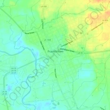
Name: Franklinton topographic map, elevation, terrain.
Location: Franklinton, Washington Parish, Louisiana, United States (30.82440 -90.17182 30.86703 -90.12189)
Average elevation: 50 m
Minimum elevation: 36 m
Maximum elevation: 71 m
Make a donation
Gear up for your next adventure:
As an Amazon Associate, this site earns from qualifying purchases at no extra cost to you.
Other topographic maps
Click on a map to view its topography, its elevation and its terrain.
Make a donation
Gear up for your next adventure:
As an Amazon Associate, this site earns from qualifying purchases at no extra cost to you.