
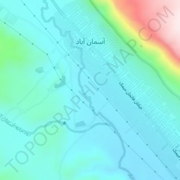
Aseman abad topographic map
Interactive map
Click on the map to display elevation.
About this map
Name: Aseman abad topographic map, elevation, terrain.
Location: Aseman abad, بخش مرکزی, Chardavol County, Ilam Province, Iran (33.84177 46.44649 33.86727 46.47370)
Average elevation: 1,264 m
Minimum elevation: 1,185 m
Maximum elevation: 1,638 m
Other topographic maps
Click on a map to view its topography, its elevation and its terrain.
Aseman abad
Iran > Ilam Province > Chardavol County > دهستان آسمان آباد > Aseman abad
Aseman abad, دهستان آسمان آباد, بخش مرکزی, Chardavol County, Ilam Province, 69561, Iran
Average elevation: 1,281 m