Geolocate

Armou topographic map

Click on the map to display elevation.

About this map

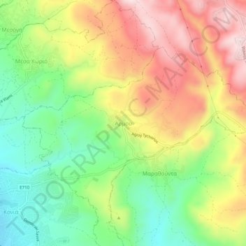
Name: Armou topographic map, elevation, terrain.

Location: Armou, Paphos District, Cyprus, 8062, Cyprus (34.77932 32.45983 34.81932 32.49983)

Average elevation: 349 m

Minimum elevation: 159 m

Maximum elevation: 570 m

Gear up for your next adventure:

🔥Emergency Fire Starters - Reliable ignition tools for survival situations in damp conditions
🛰️Outdoor GPS Navigation - Navigation devices for remote and off-grid areas
🔋Rechargeable Batteries - Eco-friendly power for headlamps and older GPS units
🔋Power Banks - Portable chargers for long outdoor trips
🥾Walking Shoes - Lightweight walking shoes for countryside and coastal paths

As an Amazon Associate, this site earns from qualifying purchases at no extra cost to you.