
Samartín topographic map
Interactive map
Click on the map to display elevation.
About this map
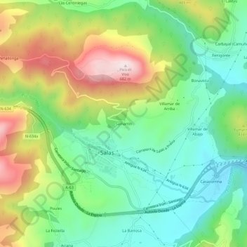
Name: Samartín topographic map, elevation, terrain.
Location: Samartín, Salas, Asturies, 33860, Espagne (43.39288 -6.27316 43.43288 -6.23316)
Average elevation: 340 m
Minimum elevation: 140 m
Maximum elevation: 681 m
Other topographic maps
Click on a map to view its topography, its elevation and its terrain.
Villamar de Abajo
Villamar de Abajo, Salas, Asturies, 33860, Espagne
Average elevation: 283 m