
Bellinghauserhohn topographic map
Interactive map
Click on the map to display elevation.
About this map
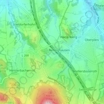
Name: Bellinghauserhohn topographic map, elevation, terrain.
Average elevation: 190 m
Minimum elevation: 112 m
Maximum elevation: 402 m
Other topographic maps
Click on a map to view its topography, its elevation and its terrain.
53639
Deutschland > Nordrhein-Westfalen > Rhein-Sieg-Kreis > Königswinter > Bellinghausen > Bellinghauserhohn
53639, Bellinghauserhohn, Bellinghausen, Königswinter, Rhein-Sieg-Kreis, Nordrhein-Westfalen, Deutschland
Average elevation: 184 m