
Sud topographic map
Interactive map
Click on the map to display elevation.
About this map
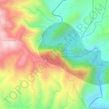
Name: Sud topographic map, elevation, terrain.
Average elevation: 203 m
Minimum elevation: 31 m
Maximum elevation: 409 m
Other topographic maps
Click on a map to view its topography, its elevation and its terrain.
Fond Des Blancs
Haiti > Sud Department > Commune d’Aquin
Fond Des Blancs, Commune d’Aquin, Arrondissement d’Aquin, Sud Department, Haiti
Average elevation: 335 m
2e Bellevue
Haiti > Sud Department > Commune d’Aquin
2e Bellevue, Commune d’Aquin, Arrondissement d’Aquin, Sud Department, 8100, Haiti
Average elevation: 151 m