
Bashkia Ura Vajgurore topographic map
Interactive map
Click on the map to display elevation.
About this map
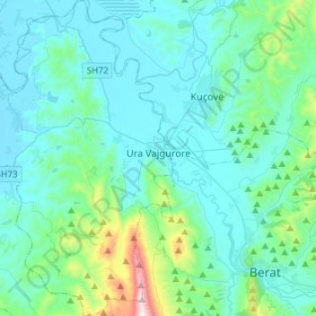
Name: Bashkia Ura Vajgurore topographic map, elevation, terrain.
Location: Bashkia Ura Vajgurore, Berat County, Southern Albania, Albania (40.67656 19.73116 40.86053 19.88930)
Average elevation: 153 m
Minimum elevation: 12 m
Maximum elevation: 1,079 m
Other topographic maps
Click on a map to view its topography, its elevation and its terrain.
Dardhë
Albania > Southern Albania > Berat County > Roshnik
Dardhë, Roshnik, Berat Municipality, Berat County, Southern Albania, 5014, Albania
Average elevation: 848 m
Donofrosë
Albania > Southern Albania > Berat County > Bashkia Ura Vajgurore
Donofrosë, Bashkia Ura Vajgurore, Berat County, Southern Albania, 5018, Albania
Average elevation: 112 m
Berat
Albania > Southern Albania > Berat County > Berat
Berat, Berat County, Southern Albania, 5001, Albania
Average elevation: 145 m