
Make a donation
Gear up for your next adventure:
As an Amazon Associate, this site earns from qualifying purchases at no extra cost to you.
Cathers Lake topographic map
Click on the map to display elevation.
Make a donation
Gear up for your next adventure:
As an Amazon Associate, this site earns from qualifying purchases at no extra cost to you.
About this map
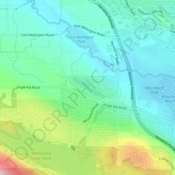
Name: Cathers Lake topographic map, elevation, terrain.
Average elevation: 119 m
Minimum elevation: 54 m
Maximum elevation: 293 m
Make a donation
Gear up for your next adventure:
As an Amazon Associate, this site earns from qualifying purchases at no extra cost to you.
Other topographic maps
Click on a map to view its topography, its elevation and its terrain.
Departure Bay
Canada > British Columbia > Regional District of Nanaimo > Nanaimo
Average elevation: 30 m
Linley Valley
Canada > British Columbia > Regional District of Nanaimo > Nanaimo
Average elevation: 76 m
Protection Island
Canada > British Columbia > Regional District of Nanaimo > Nanaimo
Average elevation: 5 m
Outer Nanaimo Harbour
Canada > British Columbia > Regional District of Nanaimo > Nanaimo
Average elevation: 7 m
Make a donation
Gear up for your next adventure:
As an Amazon Associate, this site earns from qualifying purchases at no extra cost to you.
Beach Estates Park
Canada > British Columbia > Regional District of Nanaimo > Nanaimo
Average elevation: 47 m