
Worcester topographic map
Interactive map
Click on the map to display elevation.
About this map
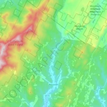
Name: Worcester topographic map, elevation, terrain.
Location: Worcester, Washington County, Vermont, 05682, United States (44.34543 -72.65434 44.47938 -72.49356)
Average elevation: 461 m
Minimum elevation: 200 m
Maximum elevation: 1,086 m
Other topographic maps
Click on a map to view its topography, its elevation and its terrain.
Montpelier
United States > Vermont > Washington County
Montpelier, Washington County, Vermont, 05602, United States
Average elevation: 284 m
Waitsfield
United States > Vermont > Washington County
Waitsfield, Washington County, Vermont, United States
Average elevation: 424 m
Waterbury
United States > Vermont > Washington County > Waterbury
Waterbury, Washington County, Vermont, United States
Average elevation: 199 m
Fayston
United States > Vermont > Washington County
Fayston, Washington County, Vermont, United States
Average elevation: 504 m
Middlesex
United States > Vermont > Washington County > Middlesex
Middlesex, Washington County, Vermont, United States
Average elevation: 330 m
Calais
United States > Vermont > Washington County > Calais
Calais, Washington County, Vermont, United States
Average elevation: 363 m
South Cabot
United States > Vermont > Washington County > Cabot > South Cabot
South Cabot, Cabot, Washington County, Vermont, 05647, United States
Average elevation: 480 m
Northfield
United States > Vermont > Washington County > Northfield
Northfield, Washington County, Vermont, 05663, United States
Average elevation: 298 m