Geolocate

Scalpay topographic map

Click on the map to display elevation.

About this map

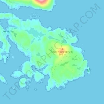
Name: Scalpay topographic map, elevation, terrain.

Location: Scalpay, The Village, Western Isles, Scotland, United Kingdom (57.84980 -6.71416 57.87938 -6.64084)

Average elevation: 11 m

Minimum elevation: 0 m

Maximum elevation: 141 m

Western Isles trails, hiking, mountain biking, running and outdoor activities

Other topographic maps

Click on a map to view its topography, its elevation and its terrain.

Gear up for your next adventure:

🥄Titanium Camping Sporks - The ultimate lightweight utensil for trail meals
🧦Merino Wool Hiking Socks - Moisture-wicking socks to prevent blisters during long mountain walks
🥤Collapsible Water Bottles - Save space in your rucksack as you consume your water
🛰️Outdoor GPS Navigation - Navigation devices for remote and off-grid areas
❄️Walking Crampons - Added traction for icy slopes and winter peak bagging

As an Amazon Associate, this site earns from qualifying purchases at no extra cost to you.