
Altzate topographic map
Interactive map
Click on the map to display elevation.
About this map
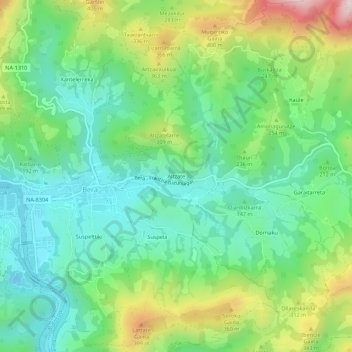
Name: Altzate topographic map, elevation, terrain.
Location: Altzate, Bera, Baztan-Bidasoa, 31770, Espagne (43.26283 -1.68615 43.30283 -1.64615)
Average elevation: 188 m
Minimum elevation: 16 m
Maximum elevation: 552 m
Other topographic maps
Click on a map to view its topography, its elevation and its terrain.
Arregi
Espagne > Navarre > Baztan-Bidasoa > Bera
Arregi, Bera, Baztan-Bidasoa, Navarre, 31760, Espagne
Average elevation: 225 m