
Isla Montague topographic map
Interactive map
Click on the map to display elevation.
About this map
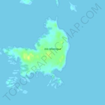
Name: Isla Montague topographic map, elevation, terrain.
Average elevation: 1 m
Minimum elevation: -2 m
Maximum elevation: 17 m
Other topographic maps
Click on a map to view its topography, its elevation and its terrain.
Isla Ángel
Chile > Region of Magallanes and Chilean Antarctica > Puerto Natales
Isla Ángel, Puerto Natales, Provincia de Última Esperanza, Region of Magallanes and Chilean Antarctica, Chile
Average elevation: 21 m