Geolocate

Loko topographic map

Click on the map to display elevation.

About this map

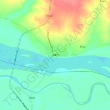
Name: Loko topographic map, elevation, terrain.

Location: Loko, Nasarawa, Nasarawa State, Nigeria (7.95797 7.80116 8.03797 7.88116)

Average elevation: 66 m

Minimum elevation: 45 m

Maximum elevation: 113 m

Gear up for your next adventure:

🪓Outdoor Multitools - Versatile tools for hiking and camping
🧘Folding Sit Mats - Dry and warm seat for map-reading breaks on damp ground
🧴Sport Sunscreen Sticks - High-protection sunblock that won't run into your eyes on the trail
📦Compression Sacks - Reduce backpack volume efficiently
👕Technical Hiking Tees - Moisture-management for high-exertion climbs

As an Amazon Associate, this site earns from qualifying purchases at no extra cost to you.