
Make a donation
Gear up for your next adventure:
As an Amazon Associate, this site earns from qualifying purchases at no extra cost to you.
Croix Scaille topographic map
Click on the map to display elevation.
Make a donation
Gear up for your next adventure:
As an Amazon Associate, this site earns from qualifying purchases at no extra cost to you.
Croix Scaille
Point culminant du versant méridional du Massif ardennais, avec 504 mètres d'altitude, il se trouve exactement à la frontière franco-belge, à la limite du département des Ardennes (commune des Hautes-Rivières), et de la province de Namur (commune de Gedinne).
Make a donation
Gear up for your next adventure:
As an Amazon Associate, this site earns from qualifying purchases at no extra cost to you.
About this map
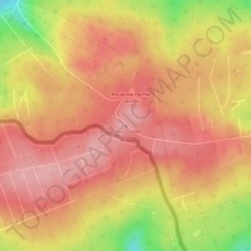
Name: Croix Scaille topographic map, elevation, terrain.
Location: Croix Scaille, Gedinne, Dinant, Namur, Wallonie, Belgique (49.95118 4.84485 49.95128 4.84495)
Average elevation: 464 m
Minimum elevation: 369 m
Maximum elevation: 508 m
Make a donation
Gear up for your next adventure:
As an Amazon Associate, this site earns from qualifying purchases at no extra cost to you.