
Thank you for supporting this site ❤️
Make a donation
Make a donation
Gear up for your next adventure:
As an Amazon Associate, this site earns from qualifying purchases at no extra cost to you.
Gaiziņkalns topographic map
Click on the map to display elevation.
Thank you for supporting this site ❤️
Make a donation
Make a donation
Gear up for your next adventure:
As an Amazon Associate, this site earns from qualifying purchases at no extra cost to you.
About this map
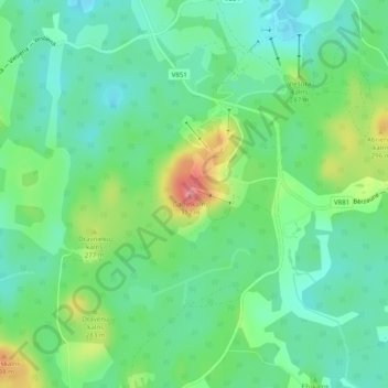
Name: Gaiziņkalns topographic map, elevation, terrain.
Location: Gaiziņkalns, Bērzaunes pagasts, Madonas novads, Latvia (56.86999 25.95931 56.87009 25.95941)
Average elevation: 250 m
Minimum elevation: 222 m
Maximum elevation: 310 m
Thank you for supporting this site ❤️
Make a donation
Make a donation
Gear up for your next adventure:
As an Amazon Associate, this site earns from qualifying purchases at no extra cost to you.