
Make a donation
Gear up for your next adventure:
As an Amazon Associate, this site earns from qualifying purchases at no extra cost to you.
Camacha topographic map
Click on the map to display elevation.
Make a donation
Gear up for your next adventure:
As an Amazon Associate, this site earns from qualifying purchases at no extra cost to you.
About this map
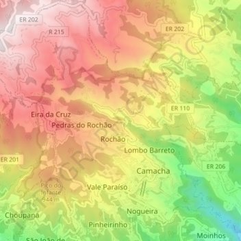
Name: Camacha topographic map, elevation, terrain.
Location: Camacha, Santa Cruz, Madeira, Portugal (32.66233 -16.89629 32.72074 -16.83027)
Average elevation: 722 m
Minimum elevation: 25 m
Maximum elevation: 1,382 m
Make a donation
Gear up for your next adventure:
As an Amazon Associate, this site earns from qualifying purchases at no extra cost to you.
Other topographic maps
Click on a map to view its topography, its elevation and its terrain.
Santo António da Serra
The parish of Santo António da Serra, located in the interior of the southern coast of Madeira, pertains to the municipality of Machico, confronted in the north and east by the parish of Porto da Cruz, west by the municipality of Santa Cruz, and by extent 20 kilometres from Funchal, the regional capital. It…
Average elevation: 624 m