
Make a donation
Gear up for your next adventure:
As an Amazon Associate, this site earns from qualifying purchases at no extra cost to you.
Choibalsan topographic map
Click on the map to display elevation.
Make a donation
Gear up for your next adventure:
As an Amazon Associate, this site earns from qualifying purchases at no extra cost to you.
Choibalsan
Choibalsan (Mongolian: Чойбалсан) is the fourth-largest city in Mongolia after Ulaanbaatar, Darkhan, and Erdenet. The name of the city was Bayan Tümen (Баян Түмэн) until 1941, when it was renamed after the communist leader Khorloogiin Choibalsan in honor of the 20th anniversary of the Mongolian Revolution of 1921. It is the capital of the province of Dornod. The city administrative unit's official name is Kherlen sum, with area of 281 square kilometres or 108 square miles. It is situated at the Kherlen River, at an elevation of 747 metres or 2,451 feet above sea level.
Make a donation
Gear up for your next adventure:
As an Amazon Associate, this site earns from qualifying purchases at no extra cost to you.
About this map
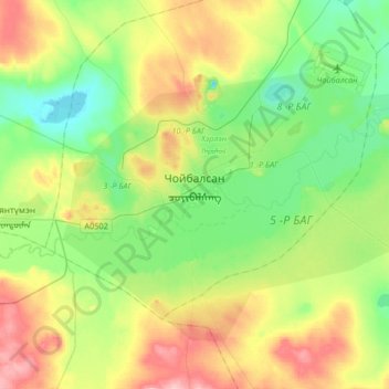
Name: Choibalsan topographic map, elevation, terrain.
Location: Choibalsan, Kherlen, Dornod, 21065, Mongolia (47.98124 114.41179 48.13378 114.74212)
Average elevation: 764 m
Minimum elevation: 714 m
Maximum elevation: 862 m
Make a donation
Gear up for your next adventure:
As an Amazon Associate, this site earns from qualifying purchases at no extra cost to you.