
Kirchdorf an der Krems topographic map
Interactive map
Click on the map to display elevation.
About this map
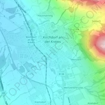
Name: Kirchdorf an der Krems topographic map, elevation, terrain.
Average elevation: 475 m
Minimum elevation: 414 m
Maximum elevation: 747 m
Other topographic maps
Click on a map to view its topography, its elevation and its terrain.
Großer Priel
Autriche > Haute-Autriche > Bezirk Kirchdorf > Hinterstoder
Großer Priel, Hinterstoder, Bezirk Kirchdorf, Haute-Autriche, 4573, Autriche
Average elevation: 1,919 m