
Make a donation
Gear up for your next adventure:
As an Amazon Associate, this site earns from qualifying purchases at no extra cost to you.
Terracina topographic map
Click on the map to display elevation.
Make a donation
Gear up for your next adventure:
As an Amazon Associate, this site earns from qualifying purchases at no extra cost to you.
Terracina
Above the town are several massive terrace platforms for supporting buildings; these may well belong to the Roman period, and the latter even to the Empire. The summit of the promontory, elevation 227 metres (745 ft), is reached by the old line of the Via Appia, which is flanked by tombs and by remains of an ancient defensive wall with circular towers, the so-called Cinta Sillana (once attributed to Theodoric, but dating from the first decades of the 1st century BCE). The summit is occupied by a large terrace, supported by arcades of fine opus incertum (traditionally, but wrongly, called the "palace of Theodoric") on all sides except the east, with views seaward over the coast and over the Pontine Marshes.
Make a donation
Gear up for your next adventure:
As an Amazon Associate, this site earns from qualifying purchases at no extra cost to you.
About this map
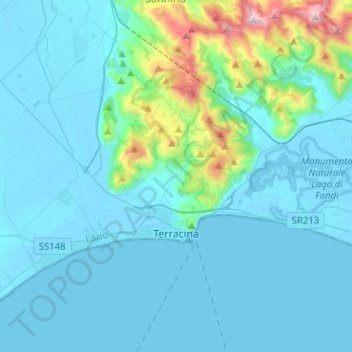
Name: Terracina topographic map, elevation, terrain.
Location: Terracina, Latina, Lazio, Italy (41.25845 13.06086 41.37844 13.31369)
Average elevation: 121 m
Minimum elevation: -4 m
Maximum elevation: 1,066 m
Make a donation
Gear up for your next adventure:
As an Amazon Associate, this site earns from qualifying purchases at no extra cost to you.
Other topographic maps
Click on a map to view its topography, its elevation and its terrain.