
Балаклавский округ topographic map
Interactive map
Click on the map to display elevation.
About this map
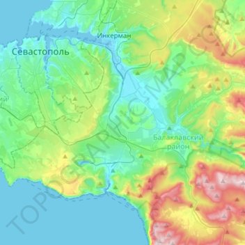
Name: Балаклавский округ topographic map, elevation, terrain.
Average elevation: 147 m
Minimum elevation: -2 m
Maximum elevation: 597 m
Other topographic maps
Click on a map to view its topography, its elevation and its terrain.
Маячная балка
Russia > Sevastopol > Inkerman
Маячная балка, Inkerman, Sevastopol, Southern Federal District, Russia
Average elevation: 47 m