Geolocate

Winchuck topographic map

Click on the map to display elevation.

About this map

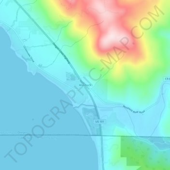
Name: Winchuck topographic map, elevation, terrain.

Location: Winchuck, Curry County, Oregon, United States (41.99033 -124.23350 42.03033 -124.19350)

Average elevation: 92 m

Minimum elevation: 0 m

Maximum elevation: 428 m

Other topographic maps

Click on a map to view its topography, its elevation and its terrain.

Brookings

United States > Oregon > Curry County

Average elevation: 131 m

Gold Beach

United States > Oregon > Curry County

Average elevation: 85 m

Port Orford

United States > Oregon > Curry County

Average elevation: 33 m

Brookings

United States > Oregon > Curry County

Average elevation: 132 m

Harbor

United States > Oregon > Curry County > Harbor

Average elevation: 71 m

Port Orford

United States > Oregon > Curry County

Average elevation: 33 m

Brookings

United States > Oregon > Curry County

Average elevation: 132 m

Gear up for your next adventure:

🍲Portable Camping Stoves - Fast-boiling stoves for hot meals on remote topographic survey trips
📻Hand-Crank Emergency Radios - Stay updated on weather warnings in remote areas
📢Survival Whistles - Essential safety gear for signaling for help in mountain fog
🛰️Outdoor GPS Navigation - Navigation devices for remote and off-grid areas
📷Camera Straps - Secure straps for carrying cameras while walking

As an Amazon Associate, this site earns from qualifying purchases at no extra cost to you.