
Make a donation
Gear up for your next adventure:
As an Amazon Associate, this site earns from qualifying purchases at no extra cost to you.
Porter Township topographic map
Click on the map to display elevation.
Make a donation
Gear up for your next adventure:
As an Amazon Associate, this site earns from qualifying purchases at no extra cost to you.
About this map
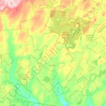
Name: Porter Township topographic map, elevation, terrain.
Location: Porter Township, Pike County, Pennsylvania, United States (41.14089 -75.15650 41.29356 -74.97358)
Average elevation: 394 m
Minimum elevation: 254 m
Maximum elevation: 585 m
Make a donation
Gear up for your next adventure:
As an Amazon Associate, this site earns from qualifying purchases at no extra cost to you.
Other topographic maps
Click on a map to view its topography, its elevation and its terrain.
Dingmans Ferry
United States > Pennsylvania > Pike County > Delaware Township
Average elevation: 192 m
Make a donation
Gear up for your next adventure:
As an Amazon Associate, this site earns from qualifying purchases at no extra cost to you.
Lake in the Clouds
United States > Pennsylvania > Pike County > Greene Township
Average elevation: 561 m
Make a donation
Gear up for your next adventure:
As an Amazon Associate, this site earns from qualifying purchases at no extra cost to you.
Lords Valley
United States > Pennsylvania > Pike County > Blooming Grove Township
Average elevation: 412 m
Make a donation
Gear up for your next adventure:
As an Amazon Associate, this site earns from qualifying purchases at no extra cost to you.
Sagamore Estates
United States > Pennsylvania > Pike County > Shohola Township
Average elevation: 412 m
Dingmans Ferry
United States > Pennsylvania > Pike County > Delaware Township
Average elevation: 192 m
Tanglewood Estate
United States > Pennsylvania > Pike County > Palmyra Township
Average elevation: 448 m
Make a donation
Gear up for your next adventure:
As an Amazon Associate, this site earns from qualifying purchases at no extra cost to you.
Masthope Rapids
United States > Pennsylvania > Pike County > Lackawaxen Township
Average elevation: 313 m
Sagamore Estates
United States > Pennsylvania > Pike County > Shohola Township
Average elevation: 412 m
Pocono Mountain Woodland Lakes
United States > Pennsylvania > Pike County > Dingman Township
Average elevation: 369 m
Make a donation
Gear up for your next adventure:
As an Amazon Associate, this site earns from qualifying purchases at no extra cost to you.
Lords Valley
United States > Pennsylvania > Pike County > Blooming Grove Township
Average elevation: 412 m
Make a donation
Gear up for your next adventure:
As an Amazon Associate, this site earns from qualifying purchases at no extra cost to you.
Saw Creek
United States > Pennsylvania > Pike County > Lehman Township > Saw Creek
Average elevation: 276 m
Make a donation
Gear up for your next adventure:
As an Amazon Associate, this site earns from qualifying purchases at no extra cost to you.