
Thank you for supporting this site ❤️
Make a donation
Make a donation
Gear up for your next adventure:
As an Amazon Associate, this site earns from qualifying purchases at no extra cost to you.
Florián topographic map
Click on the map to display elevation.
Thank you for supporting this site ❤️
Make a donation
Make a donation
Gear up for your next adventure:
As an Amazon Associate, this site earns from qualifying purchases at no extra cost to you.
Florián
弗洛里安是哥倫比亞的城鎮,位於該國東北部,由桑坦德省負責管轄,距離首府布卡拉曼加300公里,始建於1915年,面積191平方公里,海拔高度1,538米,2005年人口6,273。
Thank you for supporting this site ❤️
Make a donation
Make a donation
Gear up for your next adventure:
As an Amazon Associate, this site earns from qualifying purchases at no extra cost to you.
About this map
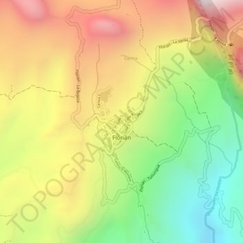
Name: Florián topographic map, elevation, terrain.
Average elevation: 1,571 m
Minimum elevation: 1,114 m
Maximum elevation: 2,000 m
Thank you for supporting this site ❤️
Make a donation
Make a donation
Gear up for your next adventure:
As an Amazon Associate, this site earns from qualifying purchases at no extra cost to you.