
Achmer topographic map
Interactive map
Click on the map to display elevation.
About this map
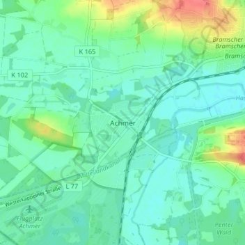
Name: Achmer topographic map, elevation, terrain.
Average elevation: 58 m
Minimum elevation: 44 m
Maximum elevation: 97 m
Other topographic maps
Click on a map to view its topography, its elevation and its terrain.
Engter
Duitsland > Nedersaksen > Landkreis Osnabrück > Bramsche
Engter, Bramsche, Landkreis Osnabrück, Nedersaksen, Duitsland
Average elevation: 87 m
Schmittenhöhe
Duitsland > Nedersaksen > Landkreis Osnabrück > Bramsche
Schmittenhöhe, Bramsche, Landkreis Osnabrück, Nedersaksen, Duitsland
Average elevation: 118 m