
Hameau es Cavelier topographic map
Interactive map
Click on the map to display elevation.
About this map
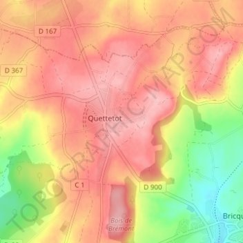
Name: Hameau es Cavelier topographic map, elevation, terrain.
Average elevation: 113 m
Minimum elevation: 29 m
Maximum elevation: 163 m
Other topographic maps
Click on a map to view its topography, its elevation and its terrain.
La Pasquerie
France > Normandie > Manche > Bricquebec-en-Cotentin > Quettetot
La Pasquerie, Quettetot, Bricquebec-en-Cotentin, Cherbourg, Manche, Normandie, France métropolitaine, 50260, France
Average elevation: 112 m