
El Santuario topographic map
Interactive map
Click on the map to display elevation.
About this map
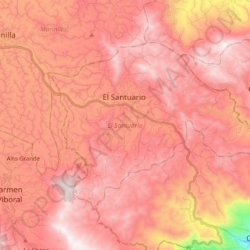
Name: El Santuario topographic map, elevation, terrain.
Location: El Santuario, Oriente, Antioquia, 054450, Kolumbien (6.07542 -75.31013 6.17108 -75.16495)
Average elevation: 2,173 m
Minimum elevation: 1,283 m
Maximum elevation: 2,541 m
Other topographic maps
Click on a map to view its topography, its elevation and its terrain.
La Piñuela
Kolumbien > Antioquia > Cocorná
La Piñuela, Cocorná, Oriente, Antioquia, Kolumbien
Average elevation: 1,109 m
San Jerónimo
San Jerónimo, Occidente, Antioquia, Kolumbien
Average elevation: 1,420 m