
Make a donation
Gear up for your next adventure:
As an Amazon Associate, this site earns from qualifying purchases at no extra cost to you.
Les Planches topographic map
Click on the map to display elevation.
Make a donation
Gear up for your next adventure:
As an Amazon Associate, this site earns from qualifying purchases at no extra cost to you.
About this map
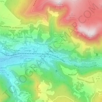
Name: Les Planches topographic map, elevation, terrain.
Average elevation: 1,113 m
Minimum elevation: 852 m
Maximum elevation: 1,477 m
Make a donation
Gear up for your next adventure:
As an Amazon Associate, this site earns from qualifying purchases at no extra cost to you.
Other topographic maps
Click on a map to view its topography, its elevation and its terrain.
Lac de Guéry
France > Auvergne-Rhône-Alpes > Puy-de-Dôme > Mont-Dore
Situé à une altitude de 1 244 m, ce lac de 25 hectares est dû à une coulée de lave qui a barré le cours d'un torrent venu du puy Gros. Il est de forme presque parfaitement ovale, et peu profond puisque sa profondeur maximum est de 18 m.
Average elevation: 1,311 m