
Longhua County topographic map
Interactive map
Click on the map to display elevation.
About this map
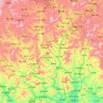
Name: Longhua County topographic map, elevation, terrain.
Location: Longhua County, Chengde City, Hebei, China (41.14382 116.79220 41.83607 118.30934)
Average elevation: 919 m
Minimum elevation: 313 m
Maximum elevation: 1,806 m
Other topographic maps
Click on a map to view its topography, its elevation and its terrain.
Xinglong County
China > Hebei > Chengde City
Xinglong County, Chengde City, Hebei, China
Average elevation: 487 m
Yuanbaoshan Subdistrict
China > Hebei > Chengde City
Yuanbaoshan Subdistrict, Shuangluan District, Chengde City, Hebei, China
Average elevation: 454 m