
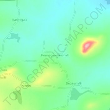
Honnegowdanahalli topographic map
Interactive map
Click on the map to display elevation.
About this map
Name: Honnegowdanahalli topographic map, elevation, terrain.
Average elevation: 868 m
Minimum elevation: 818 m
Maximum elevation: 1,004 m
Other topographic maps
Click on a map to view its topography, its elevation and its terrain.
Lakkipura
India > Karnataka > Gundlupet taluk
Lakkipura, Gundlupet taluk, Chamarajanagar District, Karnataka, India
Average elevation: 889 m
Mangala
India > Karnataka > Gundlupet taluk
Mangala, Gundlupet taluk, Chamarajanagar district, Karnataka, 571126, India
Average elevation: 959 m
Moyar
India > Karnataka > Gundlupet taluk
Moyar, Gundlupet taluk, Chamarajanagar district, Karnataka, India
Average elevation: 1,064 m
Kannegala
India > Karnataka > Gundlupet taluk
Kannegala, Gundlupet taluk, Chamarajanagar district, Karnataka, India
Average elevation: 865 m
Gundlupet
India > Karnataka > Gundlupet taluk
Gundlupet, Gundlupet taluk, Chamarajanagar District, Karnataka, 571111, India
Average elevation: 807 m