
Make a donation
Gear up for your next adventure:
As an Amazon Associate, this site earns from qualifying purchases at no extra cost to you.
Toba Inlet topographic map
Click on the map to display elevation.
Make a donation
Gear up for your next adventure:
As an Amazon Associate, this site earns from qualifying purchases at no extra cost to you.
About this map
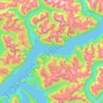
Name: Toba Inlet topographic map, elevation, terrain.
Average elevation: 795 m
Minimum elevation: -5 m
Maximum elevation: 2,182 m
Make a donation
Gear up for your next adventure:
As an Amazon Associate, this site earns from qualifying purchases at no extra cost to you.
Other topographic maps
Click on a map to view its topography, its elevation and its terrain.
Goat Island
Canada > British Columbia > qathet Regional District > Area A (Malaspina/Toba)
Average elevation: 291 m
Lund
Canada > British Columbia > qathet Regional District > Area A (Malaspina/Toba)
Average elevation: 57 m
Boyle Lake
Canada > British Columbia > qathet Regional District > Area A (Malaspina/Toba)
Average elevation: 1,401 m
Page Islets
Canada > British Columbia > qathet Regional District > Area A (Malaspina/Toba)
Average elevation: 30 m
Make a donation
Gear up for your next adventure:
As an Amazon Associate, this site earns from qualifying purchases at no extra cost to you.
Racoon Mountain
Canada > British Columbia > qathet Regional District > Area A (Malaspina/Toba)
Average elevation: 2,206 m