
Timimoun Province topographic map
Interactive map
Click on the map to display elevation.
About this map
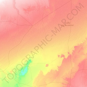
Name: Timimoun Province topographic map, elevation, terrain.
Location: Timimoun Province, Algeria (28.38192 -0.92035 31.65961 2.09147)
Average elevation: 477 m
Minimum elevation: 171 m
Maximum elevation: 875 m
Other topographic maps
Click on a map to view its topography, its elevation and its terrain.
Ouled Ayache
Algeria > Timimoun Province > Tinerkouk District
Ouled Ayache, Ksar Kaddour, Tinerkouk District, Timimoun Province, Algeria
Average elevation: 366 m
Aougrout
Algeria > Timimoun Province > Aougrout District > Aougrout
Aougrout, Aougrout District, Timimoun Province, 1012, Algeria
Average elevation: 339 m