
Thank you for supporting this site ❤️
Make a donation
Make a donation
Gear up for your next adventure:
As an Amazon Associate, this site earns from qualifying purchases at no extra cost to you.
Cheram A topographic map
Click on the map to display elevation.
Thank you for supporting this site ❤️
Make a donation
Make a donation
Gear up for your next adventure:
As an Amazon Associate, this site earns from qualifying purchases at no extra cost to you.
About this map
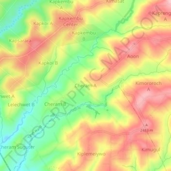
Name: Cheram A topographic map, elevation, terrain.
Location: Cheram A, Tinet ward, Kuresoi South, Nakuru, Kenya (-0.54256 35.55764 -0.50256 35.59764)
Average elevation: 2,418 m
Minimum elevation: 2,325 m
Maximum elevation: 2,499 m
Thank you for supporting this site ❤️
Make a donation
Make a donation
Gear up for your next adventure:
As an Amazon Associate, this site earns from qualifying purchases at no extra cost to you.