
Make a donation
Gear up for your next adventure:
As an Amazon Associate, this site earns from qualifying purchases at no extra cost to you.
Starr Peak topographic map
Click on the map to display elevation.
Make a donation
Gear up for your next adventure:
As an Amazon Associate, this site earns from qualifying purchases at no extra cost to you.
About this map
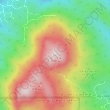
Name: Starr Peak topographic map, elevation, terrain.
Location: Starr Peak, Gilpin County, Colorado, 80471, United States (39.89355 -105.41949 39.89365 -105.41939)
Average elevation: 2,929 m
Minimum elevation: 2,694 m
Maximum elevation: 3,191 m
Make a donation
Gear up for your next adventure:
As an Amazon Associate, this site earns from qualifying purchases at no extra cost to you.
Other topographic maps
Click on a map to view its topography, its elevation and its terrain.
East Portal Distributed Camping Area
United States > Colorado > Gilpin County
Average elevation: 3,041 m
Make a donation
Gear up for your next adventure:
As an Amazon Associate, this site earns from qualifying purchases at no extra cost to you.