
Kings topographic map
Interactive map
Click on the map to display elevation.
About this map
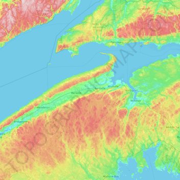
Name: Kings topographic map, elevation, terrain.
Location: Kings, Kings County, Nueva Escocia, B4R 1A2, Canadá (44.42053 -65.23458 45.70053 -63.95458)
Average elevation: 99 m
Minimum elevation: -3 m
Maximum elevation: 407 m
Other topographic maps
Click on a map to view its topography, its elevation and its terrain.
Grand Pre
Canadá > Nueva Escocia > Grand Pre
Grand Pre, Municipality of the County of Kings, Kings County, Nueva Escocia, B0P 1M0, Canadá
Average elevation: 21 m
Linwood
Canadá > Nueva Escocia > Linwood
Linwood, Municipality of the County of Antigonish, Antigonish County, Nueva Escocia, Canadá
Average elevation: 29 m
Joggins
Canadá > Nueva Escocia > Joggins
Joggins, Municipality of the County of Cumberland, Cumberland County, Nueva Escocia, B0L 1A0, Canadá
Average elevation: 54 m