
Make a donation
Gear up for your next adventure:
As an Amazon Associate, this site earns from qualifying purchases at no extra cost to you.
Marulanda topographic map
Click on the map to display elevation.
Make a donation
Gear up for your next adventure:
As an Amazon Associate, this site earns from qualifying purchases at no extra cost to you.
About this map
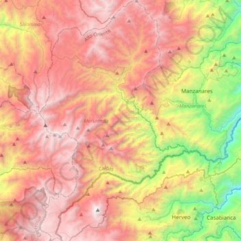
Name: Marulanda topographic map, elevation, terrain.
Average elevation: 2,667 m
Minimum elevation: 1,114 m
Maximum elevation: 3,976 m
Make a donation
Gear up for your next adventure:
As an Amazon Associate, this site earns from qualifying purchases at no extra cost to you.
Other topographic maps
Click on a map to view its topography, its elevation and its terrain.
Manizales
Manizales is the capital city of one of the smallest Colombian departments. The city is described as having an "abrupt topography", and lies on the Colombian Central Mountain Range (part of the longest continental mountain range, the Andes), with a great deal of ridgelines and steep slopes, which, combined…
Average elevation: 2,010 m
Make a donation
Gear up for your next adventure:
As an Amazon Associate, this site earns from qualifying purchases at no extra cost to you.