
Make a donation
Gear up for your next adventure:
As an Amazon Associate, this site earns from qualifying purchases at no extra cost to you.
Caucasia topographic map
Click on the map to display elevation.
Make a donation
Gear up for your next adventure:
As an Amazon Associate, this site earns from qualifying purchases at no extra cost to you.
Caucasia
The municipality of Caucasia is located at the northern department of Antioquia, on the border with the department of Córdoba and the subregion of Bajo Cauca Antioquia. It lies at an altitude of 150 m (490 ft) above sea level. Its territory is a flat area with small ridges in the north and west and south. It is one of the largest municipalities in the area due to its advantageous location, near the confluence of major tributaries, such as the river Cauca and the Nechí y Paramillo National Park.
Make a donation
Gear up for your next adventure:
As an Amazon Associate, this site earns from qualifying purchases at no extra cost to you.
About this map
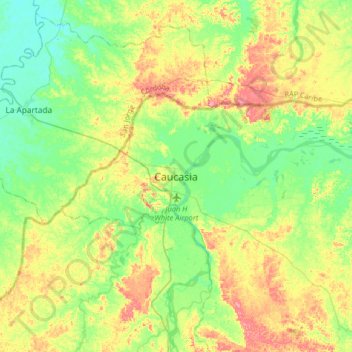
Name: Caucasia topographic map, elevation, terrain.
Average elevation: 63 m
Minimum elevation: 26 m
Maximum elevation: 126 m
Make a donation
Gear up for your next adventure:
As an Amazon Associate, this site earns from qualifying purchases at no extra cost to you.