
Akkar Governorate topographic map
Interactive map
Click on the map to display elevation.
About this map
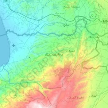
Name: Akkar Governorate topographic map, elevation, terrain.
Location: Akkar Governorate, Lebanon (34.41919 35.95440 34.69214 36.46493)
Average elevation: 636 m
Minimum elevation: 0 m
Maximum elevation: 2,736 m
Other topographic maps
Click on a map to view its topography, its elevation and its terrain.
Zahle
Zahlé is located 55 km (34 mi) east of the capital Beirut, close to the Beirut-Damascus road, and lies at the junction of Mount Lebanon and the Beqaa Valley, at a mean elevation of 1,000 m. Established in the 18th century by Christians, Zahlé maintains its predominantly Greek Catholic character. The city has…
Average elevation: 1,281 m
Deir Al Qamar
Lebanon > Mount Lebanon Governorate
Deir al-Qamar (Arabic: دَيْر الْقَمَر, romanized: Dayr al-qamar, lit. 'Monastery of the moon') is a city south-east of Beirut in south-central Lebanon. It is located five kilometres outside of Beit ed-Dine in the Chouf District of the Mount Lebanon Governorate at 800 m of average altitude.
Average elevation: 749 m
Faraya
Lebanon > Keserwan-Jbeil Governorate
Faraya (Arabic: فاريا) is a village and municipality in the Keserwan District of the Keserwan-Jbeil Governorate, Lebanon. It is located 46 kilometers north of Beirut. Elevation start from 1290 meters to 2000 meters above sea level and its total land area is 870 hectares. Faraya's inhabitants are…
Average elevation: 1,558 m
Ehden
Ehden is located in the central northern side of Mount Lebanon, with a 1500-metre (at Midan square) elevation from sea level. It is 120 kilometres (75 mi) from Beirut, 30 kilometres (19 mi) from Tripoli and 25 kilometres (16 mi) from Zgharta. Ehden used to be the sole residence for Zghartians prior to the…
Average elevation: 1,350 m
Mount Lebanon
Mount Lebanon (Arabic: جَبَل لُبْنَان, romanized: jabal lubnān, Lebanese Arabic pronunciation: [ˈʒabal ləbˈneːn]; Syriac: ܛܘܪ ܠܒ݂ܢܢ, romanized: ṭūr leḇnān, Western Syriac pronunciation: [tˤur lewˈnɔn]; Latin: Libanus) is a mountain range in Lebanon. It is about 170 km (110…
Average elevation: 2,819 m
Bsharri
Bsharri (Arabic: بشرّي Bšarrī; also romanized Becharre, Bcharre, Bsharre, Bcharre Al Arz) is a Lebanese town located in the district of the same name, North Governorate, situated at altitudes between 1,100 m (3,600 ft) and 3,088 m (10,131 ft). Bsharri is the location of the Cedars of God, a UNESCO World…
Average elevation: 1,847 m
Abey
Lebanon > Mount Lebanon Governorate
Aabey, also spelled Abey (Arabic: عبيه), is a village located in Mount Lebanon, in Aley District of Mount Lebanon Governorate. It is located 22 km (14 mi) from Beirut and has an altitude of 800 m (2,600 feet). It is bordered by Kfarmatta (South), Al Bennay (East), Damour (West), and Ain Ksour (North). It…
Average elevation: 577 m
Ras Al Matn
Lebanon > Mount Lebanon Governorate
Ras el-Matn is a town in Lebanon located on the western steep slopes of Mount Lebanon, in the upper Matn (al-Matn al-A'la) section at varying elevation between 800 and 1000 m above sea level. It's known for its panoramic views and pine trees and its location giving a view to the western sections of el-Matn and…
Average elevation: 708 m
Mazraat Al Shouf
Lebanon > Mount Lebanon Governorate
Mazraat el-Chouf (Arabic: مزرعة الشوف; also spelled Mazra'at al-Shuf) is a municipality in the Chouf District of the Mount Lebanon Governorate in Lebanon. It is located 50 kilometers southeast of Beirut. Its average elevation is 950 meters above sea level and its total land area is 1,359 hectares.…
Average elevation: 854 m
Shadra
The population is Greek Orthodox and other Christian. The village is situated at a distance of 146km from Beirut at an altitude of 450 m above sea level. It has an area of 651 hectares, surrounded by Akroum from the east, the west Owainat, from the north Machta Hassan and Andaket from the south . Can be…
Average elevation: 516 m
Baabdat
Lebanon > Mount Lebanon Governorate
Baabdat (Arabic: بعبدات) is a town located in the Matn District of Mount Lebanon, 22 km from Beirut at an altitude ranging between 600 and 1100 meters above sea level. The lush pine forests that surround the town make it a very popular summer resort for those escaping the busy coastal cities of Lebanon,…
Average elevation: 740 m
Kfar Nabrakh
Lebanon > Mount Lebanon Governorate
Kfar Nabrakh (Arabic: كفر نبرخ Kfar Nabrakh) is a municipality in the Chouf District of Mount Lebanon Governorate, Lebanon. It is located 50 kilometers southeast of Beirut. Kfarnabrakh total land area consists of 941 hectares. Its average elevation is 1,010 meters above sea level. Its inhabitants are…
Average elevation: 929 m
Aitou
With a qāf added at the beginning, as Qaitou, the name could mean in Aramaic 'summer', 'heat' or 'boar'. It is equivalent to the Arabic qaiz (قيظ), meaning 'canicule' or 'heat wave', and to Hebrew qayits (קיץ) meaning 'summer'. It could refer to Aitou being used as a summer resort, given the town's…
Average elevation: 873 m
Smar Jbeil
Smar Jbeil (Arabic: سمار جبيل, also known as "Asmar Jbeil" or "Samar Jbeil") is a village located in the Batroun District in the North Governorate of Lebanon. It is located on a hill facing the Mediterranean Sea at 500 m elevation. It is one of the oldest villages in Lebanon.
Average elevation: 331 m