
Municipal Unit of Nea Filadelfeia topographic map
Interactive map
Click on the map to display elevation.
Municipal Unit of Nea Filadelfeia
Nea Filadelfeia is a suburb of Athens, 6 km (4 mi) north of the city centre. Its built-up area is continuous with that of municipality of Athens and the surrounding suburbs Nea Chalkidona, Agioi Anargyroi, Acharnes, Metamorfosi and Nea Ionia. Motorway 1 (Athens - Thessaloniki) and Greek National Road 1 pass through the town. Nea Filadelfeia has a large park, Alsos Neas Filadelfias, which covers 0.48 square kilometres (0.19 sq mi). The park formerly hosted a large zoo which operated since 1955 to 1995. Nea Filadelfeia is roughly located at the geographical center of the Attica peninsula, around 13 km from the sea to the south suburbs and at a low elevation.
About this map
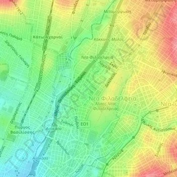
Name: Municipal Unit of Nea Filadelfeia topographic map, elevation, terrain.
Average elevation: 120 m
Minimum elevation: 79 m
Maximum elevation: 172 m
Other topographic maps
Click on a map to view its topography, its elevation and its terrain.