Geolocate

Toong topographic map

Click on the map to display elevation.

About this map

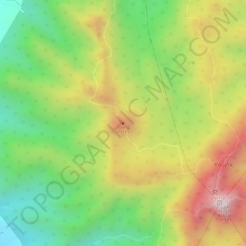
Name: Toong topographic map, elevation, terrain.

Location: Toong, Tuy, Batangas, Calabarzon, Philippines (14.04909 120.79079 14.04919 120.79089)

Average elevation: 471 m

Minimum elevation: 191 m

Maximum elevation: 775 m

Other topographic maps

Click on a map to view its topography, its elevation and its terrain.

Palico River

Philippines > Batangas > Tuy > Sabang > Palico

Average elevation: 40 m

Luna

Philippines > Batangas > Tuy

Average elevation: 75 m

Gear up for your next adventure:

🦯Walking Poles - Supportive poles for long-distance walking
🎒Hiking Child Carriers - Explore the outdoors with the whole family safely
🧼Technical Clothing Wash - Special soap to clean and restore waterproof membranes
🧗Locking Carabiners - Secure gear to your pack or for light technical use
🧼Biodegradable Soap - Leave-no-trace hygiene for multi-day mountain treks

As an Amazon Associate, this site earns from qualifying purchases at no extra cost to you.