Geolocate

Luna topographic map

Click on the map to display elevation.

About this map

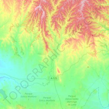
Name: Luna topographic map, elevation, terrain.

Location: Luna, Cinco Villas, Zaragoza, Aragon, 50610, Spain (42.05013 -1.05065 42.28283 -0.80478)

Average elevation: 498 m

Minimum elevation: 334 m

Maximum elevation: 836 m

Other topographic maps

Click on a map to view its topography, its elevation and its terrain.

Ruesta

Spain > Aragon > Cinco Villas > Urriés

Average elevation: 588 m

Malpica de Arba

Spain > Aragon > Cinco Villas > Biota

Average elevation: 610 m

El Pinar

Spain > Aragon > Cinco Villas > Lobera de Onsella

Average elevation: 915 m

Gear up for your next adventure:

🧣Neck Gaiters - Protects against wind and sun on exposed ridges and peaks
🧘Folding Sit Mats - Dry and warm seat for map-reading breaks on damp ground
🎿Telescopic Trekking Poles - Reduces knee strain on steep topographic descents
🔭Compact Hiking Binoculars - Lightweight optics for scouting terrain and spotting wildlife
🦶Anti-Blister Balms - Protect your feet before long topographic expeditions

As an Amazon Associate, this site earns from qualifying purchases at no extra cost to you.