
Bad Flinsberg topographic map
Interactive map
Click on the map to display elevation.
About this map
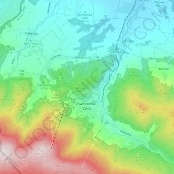
Name: Bad Flinsberg topographic map, elevation, terrain.
Average elevation: 598 m
Minimum elevation: 374 m
Maximum elevation: 1,121 m
Seit 2008 führt die Heufudergondelbahn auf eine Höhe von 1.060 m in unmittelbarer Nähe zur Heufuderbaude.
Other topographic maps
Click on a map to view its topography, its elevation and its terrain.
Ober Thiemendorf
Polen > Woiwodschaft Niederschlesien > Landkreis Lauban
Ober Thiemendorf, Gemeinde Lauban, Landkreis Lauban, Woiwodschaft Niederschlesien, Polen
Average elevation: 271 m