
Make a donation
Gear up for your next adventure:
As an Amazon Associate, this site earns from qualifying purchases at no extra cost to you.
Artesia topographic map
Click on the map to display elevation.
Make a donation
Gear up for your next adventure:
As an Amazon Associate, this site earns from qualifying purchases at no extra cost to you.
Artesia
Artesia is located in northern Eddy County at 32°50′34″N 104°24′44″W / 32.84278°N 104.41222°W / 32.84278; -104.41222 (32.842744, -104.412315), at an elevation of 3,380 feet (1,030 m). US 82 leads east 64 miles (103 km) to Lovington and west 110 miles (180 km) to Alamogordo, while US 285 leads north 40 miles (64 km) to Roswell and south 36 miles (58 km) to Carlsbad, the Eddy County seat.
Make a donation
Gear up for your next adventure:
As an Amazon Associate, this site earns from qualifying purchases at no extra cost to you.
About this map
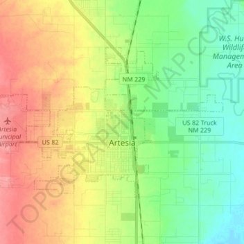
Name: Artesia topographic map, elevation, terrain.
Location: Artesia, Eddy County, New Mexico, United States (32.81721 -104.48174 32.88627 -104.34806)
Average elevation: 1,037 m
Minimum elevation: 1,004 m
Maximum elevation: 1,080 m
Make a donation
Gear up for your next adventure:
As an Amazon Associate, this site earns from qualifying purchases at no extra cost to you.
Other topographic maps
Click on a map to view its topography, its elevation and its terrain.
Make a donation
Gear up for your next adventure:
As an Amazon Associate, this site earns from qualifying purchases at no extra cost to you.