
Make a donation
Gear up for your next adventure:
As an Amazon Associate, this site earns from qualifying purchases at no extra cost to you.
Cook Island topographic map
Click on the map to display elevation.
Make a donation
Gear up for your next adventure:
As an Amazon Associate, this site earns from qualifying purchases at no extra cost to you.
About this map
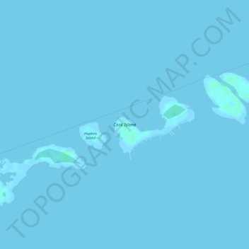
Name: Cook Island topographic map, elevation, terrain.
Location: Cook Island, Monroe County, Florida, United States (24.62753 -81.37780 24.63375 -81.36825)
Average elevation: 0 m
Minimum elevation: -1 m
Maximum elevation: 4 m
Make a donation
Gear up for your next adventure:
As an Amazon Associate, this site earns from qualifying purchases at no extra cost to you.
Other topographic maps
Click on a map to view its topography, its elevation and its terrain.
Key West
United States > Florida > Monroe County
Key West is an island located at 24°33′55″N 81°46′33″W / 24.565176°N 81.775794°W / 24.565176; -81.775794 in the Straits of Florida. The island is about 4 miles (6 km) long and 1 mile (2 km) wide, with a total land area of 4.2 square miles (10.9 km2; 2,688.0 acres). The average elevation…
Average elevation: 1 m
Make a donation
Gear up for your next adventure:
As an Amazon Associate, this site earns from qualifying purchases at no extra cost to you.
Make a donation
Gear up for your next adventure:
As an Amazon Associate, this site earns from qualifying purchases at no extra cost to you.
Florida Keys
United States > Florida > Monroe County
Tropical cyclones present special dangers and challenges to the entire Keys. Because no area of the islands is more than 20 feet (6.1 m) above sea level (and many are only a few feet elevation), and water surrounds the islands, nearly every neighborhood is subject to flooding as well as hurricane winds. In…
Average elevation: 1 m
Make a donation
Gear up for your next adventure:
As an Amazon Associate, this site earns from qualifying purchases at no extra cost to you.
Fort Zachary Taylor Historic State Park
United States > Florida > Monroe County > Key West
Average elevation: 1 m
Florida Keys
United States > Florida > Monroe County
Tropical cyclones present special dangers and challenges to the entire Keys. Because no area of the islands is more than 20 feet (6.1 m) above sea level (and many are only a few feet elevation), and water surrounds the islands, nearly every neighborhood is subject to flooding as well as hurricane winds. In…
Average elevation: 0 m
Rock Harbor
United States > Florida > Monroe County > Key Largo
Rock Harbor is located at 25°04′37″N 80°27′36″W / 25.077°N 80.46°W / 25.077; -80.46 at an elevation of 10 feet (3 m), relatively high for the Keys.
Average elevation: 1 m
Make a donation
Gear up for your next adventure:
As an Amazon Associate, this site earns from qualifying purchases at no extra cost to you.
Key West
United States > Florida > Monroe County
Key West is an island located at 24°33′55″N 81°46′33″W / 24.565176°N 81.775794°W / 24.565176; -81.775794 in the Straits of Florida. The island is about 4 miles (6 km) long and 1 mile (2 km) wide, with a total land area of 4.2 square miles (10.9 km2; 2,688.0 acres). The average elevation…
Average elevation: 0 m
Make a donation
Gear up for your next adventure:
As an Amazon Associate, this site earns from qualifying purchases at no extra cost to you.
Make a donation
Gear up for your next adventure:
As an Amazon Associate, this site earns from qualifying purchases at no extra cost to you.
Florida Keys
United States > Florida > Monroe County
Tropical cyclones present special dangers and challenges to the entire Keys. Because no area of the islands is more than 20 feet (6.1 m) above sea level (and many are only a few feet elevation), and water surrounds the islands, nearly every neighborhood is subject to flooding as well as hurricane winds. In…
Average elevation: 1 m
Make a donation
Gear up for your next adventure:
As an Amazon Associate, this site earns from qualifying purchases at no extra cost to you.
Key West
United States > Florida > Monroe County
Key West is an island located at 24°33′55″N 81°46′33″W / 24.565176°N 81.775794°W / 24.565176; -81.775794 in the Straits of Florida. The island is about 4 miles (6 km) long and 1 mile (2 km) wide, with a total land area of 4.2 square miles (10.9 km2; 2,688.0 acres). The average elevation…
Average elevation: 0 m
Make a donation
Gear up for your next adventure:
As an Amazon Associate, this site earns from qualifying purchases at no extra cost to you.
Florida Keys
United States > Florida > Monroe County
Tropical cyclones present special dangers and challenges to the entire Keys. Because no area of the islands is more than 20 feet (6.1 m) above sea level (and many are only a few feet elevation), and water surrounds the islands, nearly every neighborhood is subject to flooding as well as hurricane winds. In…
Average elevation: 1 m