
Thank you for supporting this site ❤️
Make a donation
Make a donation
Gear up for your next adventure:
As an Amazon Associate, this site earns from qualifying purchases at no extra cost to you.
Taho topographic map
Click on the map to display elevation.
Thank you for supporting this site ❤️
Make a donation
Make a donation
Gear up for your next adventure:
As an Amazon Associate, this site earns from qualifying purchases at no extra cost to you.
About this map
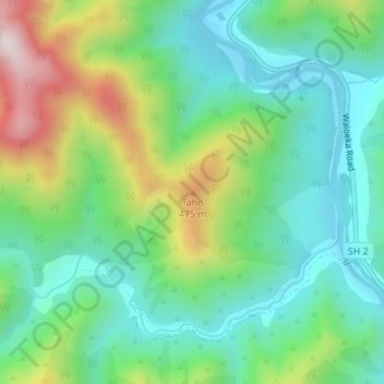
Name: Taho topographic map, elevation, terrain.
Location: Taho, Ōpōtiki District, Bay of Plenty, New Zealand (-38.19962 177.28603 -38.19952 177.28613)
Average elevation: 232 m
Minimum elevation: 53 m
Maximum elevation: 624 m
Thank you for supporting this site ❤️
Make a donation
Make a donation
Gear up for your next adventure:
As an Amazon Associate, this site earns from qualifying purchases at no extra cost to you.
Other topographic maps
Click on a map to view its topography, its elevation and its terrain.
Waiotahi River Conservation Area
New Zealand > Bay of Plenty > Ōpōtiki District
Average elevation: 153 m