
Make a donation
Gear up for your next adventure:
As an Amazon Associate, this site earns from qualifying purchases at no extra cost to you.
Balclutha topographic map
Click on the map to display elevation.
Make a donation
Gear up for your next adventure:
As an Amazon Associate, this site earns from qualifying purchases at no extra cost to you.
About this map
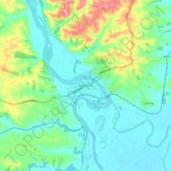
Name: Balclutha topographic map, elevation, terrain.
Location: Balclutha, Clutha District, 9230, New Zealand (-46.27780 169.69986 -46.19780 169.77986)
Average elevation: 41 m
Minimum elevation: 1 m
Maximum elevation: 152 m
Make a donation
Gear up for your next adventure:
As an Amazon Associate, this site earns from qualifying purchases at no extra cost to you.
Other topographic maps
Click on a map to view its topography, its elevation and its terrain.
Make a donation
Gear up for your next adventure:
As an Amazon Associate, this site earns from qualifying purchases at no extra cost to you.
Lake Mahinerangi
The lake is well stocked with brown trout and some perch. The elevation is nearly 2,000 feet (610 m) and the lake can be very windswept and cold, which makes the fishery best suited to the warmer months.
Average elevation: 446 m