
Make a donation
Gear up for your next adventure:
As an Amazon Associate, this site earns from qualifying purchases at no extra cost to you.
Merrill Lake topographic map
Click on the map to display elevation.
Make a donation
Gear up for your next adventure:
As an Amazon Associate, this site earns from qualifying purchases at no extra cost to you.
About this map
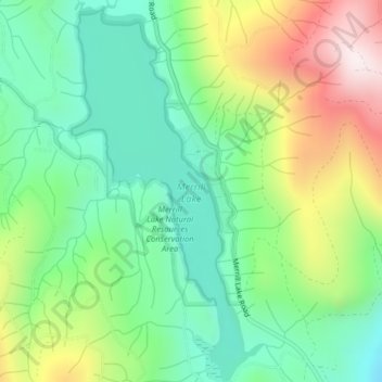
Name: Merrill Lake topographic map, elevation, terrain.
Location: Merrill Lake, Cowlitz County, Washington, United States (46.07784 -122.33303 46.10546 -122.31279)
Average elevation: 620 m
Minimum elevation: 376 m
Maximum elevation: 1,068 m
Make a donation
Gear up for your next adventure:
As an Amazon Associate, this site earns from qualifying purchases at no extra cost to you.
Other topographic maps
Click on a map to view its topography, its elevation and its terrain.
Toutle River Sediment Retention Structure
United States > Washington > Cowlitz County
Average elevation: 347 m
Toutle River Sediment Retention Structure
United States > Washington > Cowlitz County
Average elevation: 347 m
Make a donation
Gear up for your next adventure:
As an Amazon Associate, this site earns from qualifying purchases at no extra cost to you.