
Make a donation
Gear up for your next adventure:
As an Amazon Associate, this site earns from qualifying purchases at no extra cost to you.
Padre Island topographic map
Click on the map to display elevation.
Make a donation
Gear up for your next adventure:
As an Amazon Associate, this site earns from qualifying purchases at no extra cost to you.
About this map
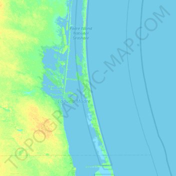
Name: Padre Island topographic map, elevation, terrain.
Location: Padre Island, Kenedy County, Texas, United States (26.52450 -97.68776 27.16450 -97.04776)
Average elevation: 3 m
Minimum elevation: -3 m
Maximum elevation: 16 m
Make a donation
Gear up for your next adventure:
As an Amazon Associate, this site earns from qualifying purchases at no extra cost to you.
Other topographic maps
Click on a map to view its topography, its elevation and its terrain.
Padre Island National Seashore
United States > Texas > Kenedy County > Corpus Christi
Average elevation: 5 m
Padre Island National Seashore
United States > Texas > Kenedy County > Corpus Christi
Average elevation: 5 m