
Make a donation
Gear up for your next adventure:
As an Amazon Associate, this site earns from qualifying purchases at no extra cost to you.
Wilsonville topographic map
Click on the map to display elevation.
Make a donation
Gear up for your next adventure:
As an Amazon Associate, this site earns from qualifying purchases at no extra cost to you.
Wilsonville
Wilsonville is located on the southern edge of the Portland metropolitan area sitting at an elevation of 154 feet (47 m) above sea level. Primarily in the southwestern part of Clackamas County, the northern section is in Washington County. It is located on the north side of the Willamette River around where Alphonse Boone established the Boones Ferry. Neighboring cities are Tualatin on the north, Sherwood to the northwest, and Canby and Aurora to the southeast. Newberg in Yamhill County is approximately 14 miles west along Wilsonville Road. The Willamette separates the majority of the city from Charbonneau, a planned community and neighborhood within the city limits, on the south.
Make a donation
Gear up for your next adventure:
As an Amazon Associate, this site earns from qualifying purchases at no extra cost to you.
About this map
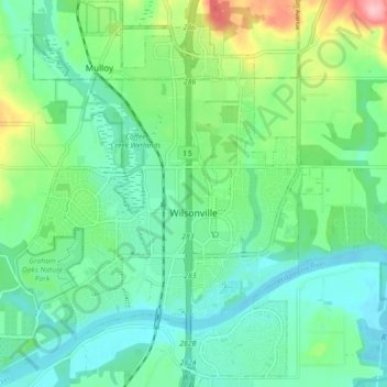
Name: Wilsonville topographic map, elevation, terrain.
Average elevation: 60 m
Minimum elevation: 18 m
Maximum elevation: 181 m
Make a donation
Gear up for your next adventure:
As an Amazon Associate, this site earns from qualifying purchases at no extra cost to you.
Other topographic maps
Click on a map to view its topography, its elevation and its terrain.
Make a donation
Gear up for your next adventure:
As an Amazon Associate, this site earns from qualifying purchases at no extra cost to you.
Bagby Hot Springs
United States > Oregon > Clackamas County
Bagby Hot Springs are natural hot springs in the Mount Hood National Forest, about 67 miles (108 km) southeast of Portland, Oregon, United States and about 98 miles (158 km) east of Salem, Oregon. The springs are in the Cascade Mountains in a heavily forested area at elevation 2280 ft (695 m). They are just…
Average elevation: 880 m
Make a donation
Gear up for your next adventure:
As an Amazon Associate, this site earns from qualifying purchases at no extra cost to you.
Mount Talbert
United States > Oregon > Clackamas County > Happy Valley
Mount Talbert is a volcanic cinder cone in Clackamas County, Oregon. It is part of the Boring Lava Field, a zone of ancient volcanic activity in the area around Portland. Its summit rises to an elevation of 740+ ft (230+ m).
Average elevation: 96 m
Make a donation
Gear up for your next adventure:
As an Amazon Associate, this site earns from qualifying purchases at no extra cost to you.
Make a donation
Gear up for your next adventure:
As an Amazon Associate, this site earns from qualifying purchases at no extra cost to you.
Boring
United States > Oregon > Clackamas County
Boring's landscape is hilly, with its elevation ranging between 548 feet (167 m) and 755 feet (230 m). Several creeks run west through the community limits into the Clackamas River, including Doane Creek, North Fork Deep Creek, and Tickle Creek.
Average elevation: 182 m
Make a donation
Gear up for your next adventure:
As an Amazon Associate, this site earns from qualifying purchases at no extra cost to you.
Make a donation
Gear up for your next adventure:
As an Amazon Associate, this site earns from qualifying purchases at no extra cost to you.
Make a donation
Gear up for your next adventure:
As an Amazon Associate, this site earns from qualifying purchases at no extra cost to you.