Geolocate

Boring topographic map

Click on the map to display elevation.

Boring

Boring's landscape is hilly, with its elevation ranging between 548 feet (167 m) and 755 feet (230 m). Several creeks run west through the community limits into the Clackamas River, including Doane Creek, North Fork Deep Creek, and Tickle Creek.

Wikipedia (CC-BY-SA 3.0)

About this map

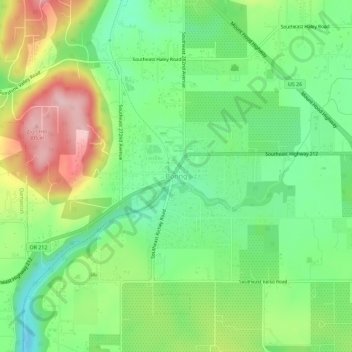
Name: Boring topographic map, elevation, terrain.

Location: Boring, Clackamas County, Oregon, 97009, United States (45.41266 -122.38951 45.45266 -122.34951)

Average elevation: 182 m

Minimum elevation: 115 m

Maximum elevation: 308 m

Other topographic maps

Click on a map to view its topography, its elevation and its terrain.

Canby

United States > Oregon > Clackamas County

Average elevation: 40 m

Sandy

United States > Oregon > Clackamas County

According to the United States Census Bureau, the city has a total area of 3.14 square miles (8.13 km2), consisting almost entirely of land. Its elevation is 967 feet (295 m).

Average elevation: 247 m

Estacada

United States > Oregon > Clackamas County

Average elevation: 176 m

West Linn

United States > Oregon > Clackamas County

Average elevation: 74 m

Oregon City

United States > Oregon > Clackamas County

Average elevation: 99 m

Molalla

United States > Oregon > Clackamas County

Average elevation: 113 m

Milwaukie

United States > Oregon > Clackamas County

Average elevation: 49 m

Lake Oswego

United States > Oregon > Clackamas County

Average elevation: 87 m

Happy Valley

United States > Oregon > Clackamas County

Average elevation: 138 m

Gladstone

United States > Oregon > Clackamas County

Average elevation: 41 m

Sandy

United States > Oregon > Clackamas County

According to the United States Census Bureau, the city has a total area of 3.14 square miles (8.13 km2), consisting almost entirely of land. Its elevation is 967 feet (295 m).

Average elevation: 247 m

Damascus

United States > Oregon > Clackamas County > Damascus

Average elevation: 160 m

Trillium Lake

United States > Oregon > Clackamas County

Average elevation: 1,174 m

Timothy Lake

United States > Oregon > Clackamas County

Average elevation: 1,035 m

Oregon City

United States > Oregon > Clackamas County

Average elevation: 99 m

Lake Oswego

United States > Oregon > Clackamas County

Average elevation: 87 m

Milwaukie

United States > Oregon > Clackamas County

Average elevation: 49 m

Happy Valley

United States > Oregon > Clackamas County

Average elevation: 138 m

Wilsonville

United States > Oregon > Clackamas County

Wilsonville is located on the southern edge of the Portland metropolitan area sitting at an elevation of 154 feet (47 m) above sea level. Primarily in the southwestern part of Clackamas County, the northern section is in Washington County. It is located on the north side of the Willamette River around where…

Average elevation: 60 m

Sandy

United States > Oregon > Clackamas County

According to the United States Census Bureau, the city has a total area of 3.14 square miles (8.13 km2), consisting almost entirely of land. Its elevation is 967 feet (295 m).

Average elevation: 247 m

Barlow

United States > Oregon > Clackamas County

Average elevation: 31 m

Gladstone

United States > Oregon > Clackamas County

Average elevation: 41 m

Trillium Lake

United States > Oregon > Clackamas County

Average elevation: 1,174 m

Glove Island

United States > Oregon > Clackamas County

Average elevation: 100 m

West Linn

United States > Oregon > Clackamas County

Average elevation: 74 m

Estacada

United States > Oregon > Clackamas County

Average elevation: 176 m

Oregon City

United States > Oregon > Clackamas County

Average elevation: 99 m

Gladstone

United States > Oregon > Clackamas County

Average elevation: 41 m

Happy Valley

United States > Oregon > Clackamas County

Average elevation: 138 m

Lake Oswego

United States > Oregon > Clackamas County

Average elevation: 87 m

Canby

United States > Oregon > Clackamas County

Average elevation: 40 m

Estacada

United States > Oregon > Clackamas County

Average elevation: 176 m

Rock

United States > Oregon > Clackamas County

Average elevation: 45 m

Happy Valley

United States > Oregon > Clackamas County

Average elevation: 138 m

Gear up for your next adventure:

🔥Reusable Hand Warmers - Maintain dexterity in your fingers for precise map handling
🪢Paracord - Multi-purpose cord for camping and survival
🐕Hiking Dog Harnesses - Rugged harnesses for taking your companion on mountain trails
🧢Thermal Beanie Hats - Prevent heat loss from the head in windy summit conditions
🧣Fleece Neck Warmers - Extra insulation for winter topographic surveys

As an Amazon Associate, this site earns from qualifying purchases at no extra cost to you.