Geolocate

Scheßlitz topographic map

Click on the map to display elevation.

About this map

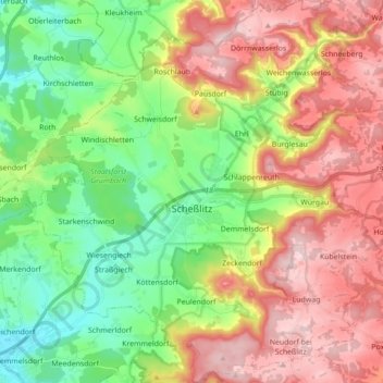
Name: Scheßlitz topographic map, elevation, terrain.

Location: Scheßlitz, Landkreis Bamberg, Bavaria, 96110, Germany (49.92579 10.95844 50.03801 11.12611)

Average elevation: 395 m

Minimum elevation: 254 m

Maximum elevation: 575 m

Other topographic maps

Click on a map to view its topography, its elevation and its terrain.

Wind

Germany > Bavaria > Landkreis Bamberg

Winds can shape landforms, via a variety of aeolian processes such as the formation of fertile soils, for example loess, and by erosion. Dust from large deserts can be moved great distances from its source region by the prevailing winds; winds that are accelerated by rough topography and associated with dust…

Average elevation: 284 m

Mühlendorf

Germany > Bavaria > Landkreis Bamberg

Average elevation: 300 m

Neuhausen

Germany > Bavaria > Landkreis Bamberg

Average elevation: 331 m

Treppendorf

Germany > Bavaria > Landkreis Bamberg

Average elevation: 328 m

Ebing

Germany > Bavaria > Landkreis Bamberg

Average elevation: 260 m

Wiesengiech

Germany > Bavaria > Landkreis Bamberg > Scheßlitz

Average elevation: 305 m

Würgau

Germany > Bavaria > Landkreis Bamberg > Scheßlitz

Average elevation: 472 m

Gear up for your next adventure:

🥾Women's Waterproof Hiking Boots - High-performance trekking boots designed for all-weather comfort
🧢Waterproof Hiking Hats - Keep the rain off your face while studying topographic maps
🖼️Topographic Map Art - Decorative 3D-effect posters of famous UK peaks and regions
🔥Reusable Hand Warmers - Maintain dexterity in your fingers for precise map handling
📷Camera Straps - Secure straps for carrying cameras while walking

As an Amazon Associate, this site earns from qualifying purchases at no extra cost to you.